I am proud to show off the work of my nephew, James Rose, a young and talented student software developer, .
Myself, not being absolutely happy with the way in which current navigation displays show traffic, I wanted something clearer and less cluttered and a separate dedicated traffic display.
Also, I find assimilating the track, relative height and climb / decent information on the "birds eye view" style traffic displays not as intuitive it could be, hence Radar3D was born.
The typical TIS display puts your view directly above your own aircraft.
Radar3D positions your 'view' behind and above your own aircraft so that other aircraft can be show in a perspective view.
Your own aircraft is shown in the centre of the "Radar disc".
The relative height of other aircraft is shown with a vertical "tape measure", stopping at your level, either from above or below.
Track is shown by a direction line attached to the intruder aircraft.
Climb / decent / level flight is presented as a square for level flight, upward or downward triangles show the change the vertical separation of the intruder.
It is quick to distinguish which aircraft is the greatest threat without needing to read individual heights and climb information found on a typical TIS type display.
Photo below is of simultaneous screen grabs from sky demon (which I use and find excellent) and Radar3D showing a direct comparison of Radar3D and other style of display.
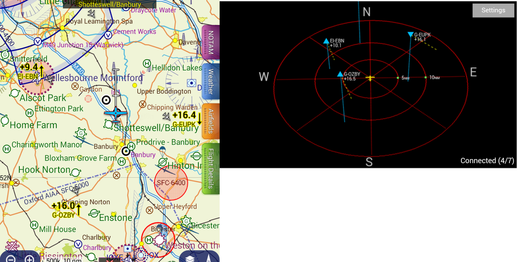
Next screen shot shows that the highest risk intruded is the aircraft with no "tape measure" and is at or close to your level, also on a converging track.
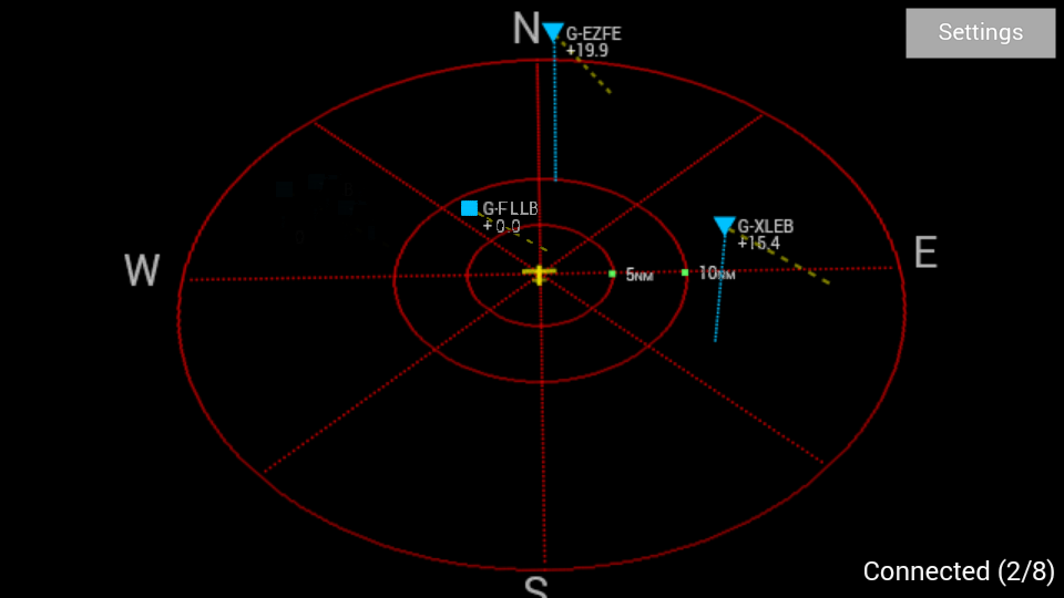
Photo showing an aircraft below but climbing towards your level, low threat as is passing behind.
The radar display operates in Track up mode so that all other aircraft positions are shown relative to your own heading.
The display can be configured to suit, being able to set the distance of the range rings and also to ignore aircraft above or below your level by any preferred figure, etc etc.
i.e. you can set the display to show aircraft withing reception range of over 100miles or set to a more local level of 5 miles range and +- 2,000ft for example.
The display will show all traffic received by Pilot Aware and also show mode C and Mode S warning banners.
Radar3D connects to Pilot Aware wirelessly and is intended to be loaded onto a smart phone or tablet (currently android only).
Radar3D is
IN BETA TEST. i.e for testing and evaluation.
If you choose to install and use the application, it is on the understanding that it is used entirely at you own risk.
Familiarisation with the APP is recommended whilst being on the ground and if any airborne tests are to be made, it is advisable to do this whilst only being a passenger. As always, do not allow any device to become a distraction. To reiterate, it is used entirely at you own risk.
The application if free :thumleft: to download and to use without any time limitation.
James would be grateful of any suggestions, improvements and reports of bugs / feedback, and for even the smallest of donations to help with the continuation of development.
More info will be loaded into the Pilot Aware forum Ecosystem.
Please see his web page where more information can be found as well as a link to the Google App store where the application can be downloaded (or search Radar3D on the app store).
http://www.jameserose.co.uk/radar3d.htmlKing regards,
Uncle Deker.